by Murli Menon
I started from Ahmedabad and reached Kathmandu (4,593 feet above sea level) via New Delhi, having been invited by Rotary Club of Mount Everest, among four others to address their members on “Stress Management through ZeNLP meditation” It was during one such talk I met Mr. Dipendra of Air Travel Pvt. Ltd. Dipendra had organized a small group of tourists who were going on a trek to Mount Kailash and Mansarovar. Dipendra requested me to join this group, as one of the tourists had dropped out at the last minute.
It was decided we would proceed to Mount Kailash through Kodari border between Nepal and Tibet on 30th May’2014. We rose early at 4 a.m. and prepared for our 5 hour road journey to Kodari on the Nepal Tibet border. We left Kathmandu at 6:00 a.m. The journey was pleasant and took us to the hill station of Dhulikhel (5500 feet), through the historic town of Bhaktapur. We stopped for some black tea with fresh mint and ginger at a tiny tea shop overlooking the Kathmandu valley! We drove along the banks of the Kotha Kosi river all through this 114 km. drive.
After reaching Kodari, being a strict vegan, I feasted on some delicious Chinese peaches and fresh strawberries at the border town of Kodari. After completing customs and immigration formalities on the Nepal side, we crossed over the Friendship Bridge between Nepal and Tibet on foot before completing the customs and immigration formalities on the Chinese side and proceeding to the Toyota Land Cruiser waiting for us at the border. This Land cruiser would be my second home for the next two weeks.
We drove 16 km. from Nyalam to Milarepa caves. The Buddhist monk, Milarepa meditated at these caves for long years. The water from the Milarepa Lake near these caves is considered sacred by local Tibetans. Large terraced barley fields, irrigated by mountain streams can be seen strewn across the Nyalam valley. One can also see many chortens, monasteries and Buddhist temples along the way. Prayer flags flutter in the violent gusts of wind. Toothless Tibetan men and women, can be seen whirling prayer wheels or chanting with a necklace of beads in their hands. One had roasted potatoes with mint and Tibetan spinach soup along with a neighbourhood Tibetan man named Sonam. Local Tibetans are courteous and friendly. Chinese presence is limited to a petrol pump run by China Petro, China Telecom and China Post.
We start in the wee hours of the morning to be able to complete the 280 km. drive between Nyalam and Saga (13,500 feet) before nightfall. This picturesque drive is a geologist’s delight. From the greenery of Nyalam to the snow-capped peaks around Paiku Tso lake, to the barren mountains around Saga, the landscape is ever changing. As one makes the tortuously slow ascent towards Saga, the vegetation cover slowly disappears. From trees to bushes to shrubs too cacti, one can see the effects of the diminishing oxygen levels. We cross the windy Lalungla Pass (16,700 feet) and drive across the Shishabangma High Altitude National Park. The most picturesque part of the journey begins as one reaches the fringes of the deep blue Paiku-Tso lake. Paiku-Tso is one of the highest sweet water lakes in the world. One can also see Sishapangma peak (27000 feet) during this drive. One can see a group of Tibetan horsemen riding into the sunset like cowboys, with cowboy hats to match! One drives along the western shore of this lake for about three hours. It almost seems as if a bit of the Pacific Ocean is resting between a circle of snow capped peaks. One can experience the power of nature to its fullest during this journey. As we near Saga, we find a change in the landscape and drive alongside a mountain stream for long hours.

One is surprised to learn that this mountain stream is none other than the mighty Brahmaputra and Saga is one of the towns on its banks. The Tibetans call this river the Yarlung Tsangpo (means mighty river). One crosses the Brahmaputra and reaches the army camp of Saga by dusk and take well deserved rest to prepare for the tough journey from Saga to Paryang. Saga is a slightly bigger town than Nyalam and appears to be in the middle of a high altitude desert. The bridge over the Brahmaputra has been constructed recently and in the erstwhile days, one had to cross the Brahmaputra in rafts, land cruisers and all. One starts early in the morning from Saga to complete the 260 km. drive to Paryang (14,200 feet) by nightfall This 9 hour drive is over a mud road. The terrain was spectacular. Giant barren mountains lined both sides of the dusty track. The sky was cobalt blue with snowy clouds suspended all over the horizon. There were few traces of human settlements along the way except a few tents of the Bon Pa, a nomadic tribe that have existed in this hostile environment since centuries. The Bon Pa’s are strict vegans and nature worshippers.
They believe in worshipping the sun, water and earth. They were the original inhabitants of Tibet before the advent of Buddhism. We stop at Old Tongba for a refreshing meal of boiled spinach, and roasted potatoes washing it down with several cups of green Tibetan tea. The villagers are friendly and one can see mountain goats and dogs here. Several Tibetan women wearing huge silver waistbands can be seen begging at street corners. The advent of the Han Chinese has played havoc with the self sustaining Tibetan economy which was based on the principles of trust and barter. The introduction of the Chinese Yuan as a form of currency has pushed millions of rural Tibetans towards poverty and starvation.
After a quick lunch, we departed from Old Tongba and refuels at the petrol pump at New Tongba. This is the last fuel station before Saga. A Toyota land cruiser can travel 750 km. on a full tank. The drive from New Tongba to Saga was a revelation. Sand-dunes stretched from one end of the horizon to the other. A frozen desert stretching for hundreds of kilometers. The weather is extreme. Mornings are freezing cold. Afternoon is blazing hot and icy high velocity winds at night. Nature tests one like never before. There is no habitation for miles except a few widely scattered Bon-Pa settlements. Occasionally, a few nomads are seen walking along the dusty road. There are grasslands around the lakes enroute. One can see a few yaks lazily grazing on the grass. Paryang is a small village which is primarily a night halt for travelers. All the homes at Paryang double up as a guesthouse for trekkers, pilgrims and tourists. One is transported to deep sleep the moment one hits the bed and wakes up to feel one’s toe freezing! In a few hours one is back into the land cruiser driving towards Mansarovar lake which is 280 km. away from here.
This drive is over rocks, pebbles, gravel and stones. There is neither a road, nor a mule track. One crosses the Mayum La pass (17000 feet) on the drive from Paryang to Mansarovar. One can only see large tracts of barren land, snowy peaks and sandy hills all along the way. One reaches Chiu Gompa after this eight hour cross country drive. On a clear day, both Mount Kailash and Mansarovar are visible from Chiu Gompa. Tibetans come here to offer their clothes as a symbolic gesture of sacrificing their ego. The monastery in Chiu Gompa is strewn with thousands of pieces of discarded robes. Stones are delicately balanced one above the other in an ancient ritual aimed at propitiating Sun (fire), Lake Mansarovar (water) and Mount Kailash (earth).
One stays the night at Chiu Gompa, camping alongside Mansarovar (14950 feet) in a windproof tent. Mansarovar is nearly 90 km. in length and covers an area of 320 sq. km. Spending the night alongside this lake is a magical experience. Thousands of stars are reflected in the crystal clearness of the lake and presents a spectacle of unparalleled beauty and expresses the power of nature as no other. The clear skies, the altitude and the pitch darkness combine to create an energy aura which has to be felt to be believed. Every year only 5000 Indian pilgrims are fortunate to make this holy pilgrimage.
One wakes up at 4 a.m. and heads for the hot water springs at Chiu Gompa for a refreshing warm water bath. These sulphur springs are known for their medicinal properties. One spends the day at Mansarovar, bathing in its freezing waters and circumambulating the lake on our land cruiser. Also visited Rakshas Tal, the mythical lake where Ravana meditated on Shiva. Rakhas Tal is extremely sceanic, especially at sunrise and sunset. The water is famed for its medicinal properties and is good for the skin. One spends the second night at Mansarovar and leaves the next day to start the Kailash Parikrama from Darchen. The ice cold dip in the freezing waters of the world’s highest sweet water lake is nothing short of a divine experience.
Mansarovar is the source of the Indus, Brahmaputra, Karnali, Mekong and Sutlej. The biting cold coupled with the freezing waters tend to make your body numb for a few minutes. However, the numbness disappears as suddenly as it appears and one can enjoy the first rays of the rising sun, reflected on the waters of this mini-ocean. Time flashes by and very soon we are watching the golden rays of the setting sun light up the evening sky. The lake reflects molten gold as the horizon turns pink and crimson. The deep reddish hue of the sky is a stark contrast to the deep blue waters of the lake, setting a distinctive mark between the sky and the water. The distance from Chiu Gompa to Darchen is 52 km and takes about two hours on a land cruiser. We started our Kailash Parikrama on foot from Darchen (15200 feet). The first part of the trek entails trekking 12km. from Darchen to Diraphuk. One is armed with assorted dry fruits including dates, almonds, raisins and walnuts alongwith roasted pumpkin seeds. One’s battery operated walkman, ZeNLP tribal music cassettes and meditation cassette are neatly packed into one’s ruck-sack. An empty wooden water bottle is an asset. One can see the west face of Kailash during this trek. This trek is alongside a flowing mountain stream. One slowly trudges overhill and treks over the narrow mountain trail which runs parallel to the stream. One travels alongside the La Chu river through a serene, meadow-lined valley, hopping over small streams, with the west face of Mount Kailash above us. The river enters a narrow canyon with several cliffs and cascading waterfalls.
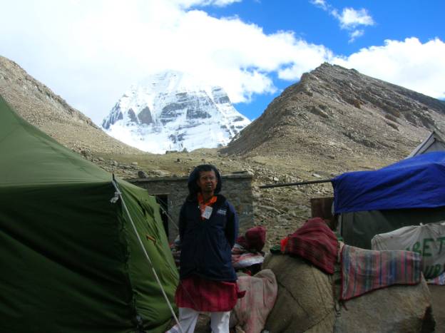
Continuing our trek, the north face of Kailash comes into view just as we arrive at Diraphuk. We cross a small bridge and follow a small path, which has magnificent views of the north face of Kailash. We camp in a tent, under the north face of Kailash. Unfortunately, the day we reached Dirapuk, the weather turned cloudy and an unnatural fog enveloped Mount Kailash. The visibility was almost near zero and one was confined to one’s tent. There was nothing to do except spent the night inside the tent.
A walk up to the ridge overlooking the north face at Diraphuk offers the closest view of Mount Kailash. In Kerala where it rains throughout the day for three to four months, my grandmother had a traditional chant for keeping away the rain by acattering the clouds. Before we stepped out of the house in Kerala, our grandmother made us recite the fifteen names of Arjuna from the Bhagavad Gita. These fifteen names if repeated mentally had the instant power to scatter the clouds and dissolve them into thin air. Continued mental or oral chanting had the power of protecting the chanter from lightning, thunder, hailstorms, avalanches and snow storms. After having spent 2000 U. S. Dollars to the atheist Chinese Government towards Tibet permit and land-cruiser charges for getting a tiny glimpse of Mount Kailash and for nine dips at Holy Mansarovar; After an ice-cold dip in the freezing waters of the snowy river, I finished chanting nine malas (108 beads ) of the gayatri mantra at the base of Mount Kailash (covered in mist and fog) between 3 a.m. and 4 a.m. as I had been doing since my childhood during the Brahma Muhurt. After completing my gayatri japa, I started chanting the fifteen names of Arjuna mentally (one cannot forget even one name from the fifteen, or refer to a book or paper). It has to be from memory and it has always worked for me. As I had learned it when I was young, I started continuously chanting the fifteen names of Arjuna in my mind and being a ZeNLP trainer sice last 20 years, I also knew the power of creative visualisation. Alongwith my silent chanting, I started visualizing the clouds disappearing, the mist dissolving and the fog fading Away into oblivion. After that I mentally visualised a golden sunrise over Mount Kailash, taking exactly the same time to visualize as it would have taken in real life. First I visualised a strong gust of wind, blowing away the clouds. Then I visualised the fog dissolving into thin air. Then the mist disappeared. Slowly, I visualised Mount Kailash appearing into view. Then, I visualised the first rays of the sun strike the peak of Mount Kailash till I could see Mount Kailash reflecting a crimson hue. I had creatively visualised one of the most spectacular sunrises, I could have ever creatively visualised. All throughout my visualisation, I continued to mentally chant the fifteen names of Arjuna. I went to deep restful sleep after the chant. Suddenly, I woke up seeing myself walking up to Mount Kailash and watching the sunlight reflected on the snow capped peaks. I was delighted that my chanting had worked in less than 15 minutes, but I was wrong. I found, I had woken up from a realistic dream, but was continued to be enveloped in mist, fog, snow and clouds in my tent. I drtifted off to sleep again after hastingly scribbling my diary with the events that unfolded. And when I actually woke up I could see that my visualisation had actualized and I could see Mount Kailash as clearly in the twilight hours of dawn, as I could see on a clear cloudless sunny afternoon. I armed myself with my digital camera, which could click only a few more photographs, as my battery had not been recharged since I left Kathmandu, as there is no electricity in most villages of Tibet.
I started to walk around my tent and scanned the eatern horizon for the sun. I could see the darkness give way to light. After about an hour as soon as I could see the rising sun, I wrelcomed it by chanting nine malas of the gayatri mantra followed by a surya namaskar on the foot of Mount Kailash. I chanted all the names of the the Sun-God as per the surya namaskar and lo behold, I was witness to one of the most spectacular sunrises, I have ever seen in my life. My digital camera which is my trusted friend over the last two decades, did not let me down at this crucial stage. I could click one photograph of the sunrise, with the sunlight creating the head of Nandi – the celestial vehicle of our beloved Lord Shiva, on the peak of Mount Kailash. After I clicked this photograph and posted on my blog after returning to Kathmandu, hundreds of travel agents in Kathmandu started printing my photograph in their brochures and evrytime I visit a travel and tourism exhibition, I head for the Nepal Tourism stall and am delighted to find my photograph inviting prospective tourists to do the trek around Mount Kailash.
One begins the 22 km. trek from Diraphuk to Zutulphuk, the next morning. One now leaves the Lha Chu Valley just as the sunrise turns the snow peaks gold and pink, and enter the Dolma Chu Valley, heading up towards the 18500 feet high Dolma La. This was bound to be a tough trek over the Dolma La pass. This pass is covered with snow throughout the year and today was no exception. One climbed almost 3000 feet, during the 6 km. trek to the top of this pass. The area was full of glaciers and surrounded by snowy peaks. After the slow descent from Dolma La , one came across a wide expanse of snow and ice. The trek over the snow was adventure of a different kind. Stepping gingerly on the slippery snow, one gets a bird’s eye view of Gauri Kund, the highest lake in the world. The descent was as difficult as the ascent as the path was covered with snow and one had to trek over kilometers of soft snow before one reached a small settlement of Tibetan nomads known as Dolma village. The make shift tea shops at Dolma village served green tea, energy drinks (Red Bull) and fruits. One stretches one’s legs at Dolma village. From Dolma village, it was a slow and steady 12 km. uphill trek. Although the altitude makes the trekking difficult, the masses of pilgrims performing their acts of devotion along the way are continuously intriguing.
Those extremely devout pilgrims prostrate themselves the entire way around Kailash, kneeling down and extending their bodies and hands in front of them in prayer (and marking the beginning of the next prostration). The trail is lined with sacred sites, coin and flag-covered rocks, rocks with footprints of saints, rocks to climb over, under or through and hillsides of discarded clothes as offerings .It’s a tough climb to the prayer-flag festooned summit, but it’s all worth if from the top as juniper incense burns and thousands of colorful prayer flags send prayers out into the surrounding valleys. One stops for lunch before the descent to the east valley. Below us lies the Lake of Compassion, Thukpe Dzingbu or Gauri Kund, one of the highest lakes in the world!
The diversity of the terrain is unbelievable. From snowy peaks, to craggy rocks to barren slopes to ice capped mountains, one could see them all. Vegetation was restricted to a few clumps of grass or a patch of shrubs amidst the barren land. Another seven hours of bright early morning trekking along a boulder-filled river brings us to Zutulphuk Gompa (17,900 feet), with Milarepa’s meditation cave and imprints of his hand and foot. It’s a tough walk along some impressive gorges and around many mani stones and mani walls. After the footbridge, the trail rises up a rocky slope. One gently but steadily keeps climbing over pebbles, rock, grass, mud and streams. One soon reaches a level walk and the peak of Mount Kailash rises to the right and can now be seen linked to a long spur, which joins the eastern ridge. This is the top edge of the glacial valley from which the Lha Chu (Divine River) flows. One spends the night in a wind-proof tent along the banks of the river before completing the final trek of the kora. One sets off as the sun breaks over the ridges above for this 22 km. trek of uninhabited valleys to the nearest mud road, where we board the land cruiser for a 4 hour drive to Gurla Mandhata. This is the most challenging part of the trek. The kora is finished – one has erased one’s sins, endured extremely cold nights and mornings, crossed one of the highest passes in the world, met countless fellow pilgrims and sent prayers of peace out to the world. One spends the night along the eastern shore of Mansarovar with Mount Gurla Mandhata to one’s right and Kailash to one’s left. Innumerable snow capped peaks can be seen all around. The water is turquoise blue, clean and fresh. One fills up the jerry can of water for carrying back to India for family and friends. Meditating on the banks of this lake at dawn and dusk was a soothing experience. The return trip from Kailash and Mansarovar takes four nights, one night each at Paryang, Saga, Zhangmu and Kathmandu. Finally one flies back to Ahmedabad via Delhi with the holy water, Tibetan souvenirs and atma lingas (pebbles that fall off Kailash when gayatri mantra is chanted at the base at dawn or dusk). I am safely home after one of the closest experiences a human being can have with fire, water and earth, the primordial elements!
About the author:
Murli Menon, is a travel writer, stress management consultant and author based at Ahmedabad, India. He is the author of “ZeNLP-Learning through stories” published by The Written Word Publications, “ZeNLP-the power to succeed” published by Sage publications and “ZeNLP-the power to relax” by New Dawn Press. He can be reached at ceo@tips4ceos.com